Advanced Astrolabe Functions: Estimating the direction to Mecca.
- on 03.10.14
- Astrolabes General, Sine Quadrant
- Comments Off on Advanced Astrolabe Functions: Estimating the direction to Mecca.
Given that the math and sciences of the Middle East were a major driving force in the development of the astrolabe[1], it is reasonable that some of the advanced functions are related to the dominant religion of the area, Islam. Today we will discuss using two of the astrolabe’s advanced features to estimate the direction of Mecca.
For a Muslim, knowing the direction to Mecca from one’s current position is not just important because of the requirement to pray in that direction five times daily. In addition, the ritual butchering of food animals needs to be done with that direction in mind for the meat to be acceptable to the dietary laws; and when bodies are buried, they need to be placed on their sides, facing toward Mecca[2]. The specific location of the Kabaa, the focus of prayer is 21.4N 39.8E[3].
Determining this direction, known as the Qibla, is a major subject in Islamic mathematics. The Qibla is defined as being the “Great Circle” direction between a given point and the location of Mecca[4]; and there are many treatises devoted to computing it accurately. But in the case of a traveler, without access to intricate mathematics or carefully computed tables, finding the proper direction is tricky.
There are two scales to be found on the back of a typical astrolabe of the region that can help with this problem.
Estimating the Qibla using the Sine/Cosine scale
It is possible to get a rough estimate of the qibla direction by using the Sine/Cosine scale to be found on the back of many astrolabes[5]. To use this scale the user must know the latitude and longitude of Mecca, as well as their own current latitude and longitude[6].
To use the sine/cosine scale, work the problem as follows:
- First, find the difference in latitude between the two positions
- Next, find the difference in longitude.
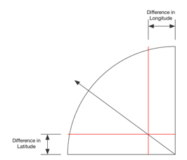
- Set the pointer or alidade of the astrolabe to point at an angle from horizontal equal to the difference in latitude. Mark the line from there to the sine scale mentally.
- Set the pointer or alidade to point at an angle from vertical equal to the difference in longitude. Mark the line from there to the sine scale mentally.
- Set the pointer to the point where the two lines cross. The pointer will now point to a direction. You will need to determine whether the direction given is to the North, South, East, or West. For example, if you are North and East of Mecca, the qibla direction will be measured from West.

Example:
Finding the Qibla from Alexandria Egypt (location: 31.2N 30.0E)
The difference in latitude (rounding off) is: 10 degrees
The difference in longitude is: 10 degrees
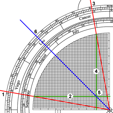
Work the problem as below: Measure up ten degrees from the horizontal scale(1) for the difference in latitude(2), and ten degrees from the vertical scale(3) for the difference in longitude(4). Place the rotating arm on the intesection of the two imaginary lines(5) and it will point at an angle(6), 45 degrees in this case. As Mecca is east and south of Alexandria, this angle will be the angle south of due East. So add it to 90 degrees to get the compass bearing (135 degrees). Using the ruler function in Google Earth (which conveniently uses great circles) The great circle direction to Mecca is 135.68 degrees.
Determining the Qibla using the Qibla line on the arcs of the signs scale
On many astrolabes there is a scale that shows the altitude of the Sun at Noon for every day of the year. This scale is in the form of a series of ninety-degree arcs marked with the various zodiac symbols representing the location of the sun on the ecliptic. In addition to one or more curved lines representing the altitude of the Sun at noon, many of these are also marked with a set of arcs labels as major cities. These arcs can be used to determine the direction of the Qibla if the user is near one of the cities listed.
To determine the rough Qibla direction using the arcs of the signs, do as follows:
– find the Sun’s position on the zodiac using the zodiac and calendar rings of the astrolabe.
– Find the city line for the city you are near.
– Find the point on that line that is in the arc for the sun’s current zodiac position.
– Set the astrolabe’s alidade/pointer to touch this point. The alidade will point to an angle on the rim.
– When the sun is at this angle above the horizon, it will sit directly above the Qibla direction.
Example: Find the direction to Mecca from near Bagdhad Given the date is the Spring Equinox (March 20th).
- First find the position of the Sun on the ecliptic for the Spring Equinox (I cheated to simplify. The First Point of Aries marks the Spring Equinox, no need to look it up).
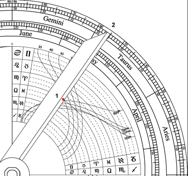
- Rotate the alidade/pointer to the point where the Bagdhad line crosses the arc marking Aries 0 (1) and it will point to an angle(2). In this case, for this date, 55 degrees. So when the sun is at an angle of 55 degrees, it is shining directly over the point on the horizon that marks the direction to Mecca.
Limitations
Clever as these techniques are, they are limited in usefulness. As the Qibla is a great circle line between points on the globe, the further you are from Mecca, the more inaccurate the estimate found by the first method will be. For example in the city of Casablanca (location:33.5N 7.5W) the Qibla direction is about 93.5 degrees but if you estimate it using the sine/cosine scale you get a direction of 106 degrees.
The second, arcs of signs, method is similarly limited. It does provide the great-circle direction, but because the sun has to be up and in the direction of Mecca to work, it is pretty much limited to locations within 90 degrees of Mecca.
Notes:
[1]Morrison, James E., The Astrolabe, Janus, 2007, pg. 31
[2]King, David A. and Lorch, Richard P., “Qibla Charts, Qibla Maps, and Related Instruments”. The History of Cartography, Volume 2, Book 2: Cartography in the Traditional East and Southeast Asian Societies, University Of Chicago Press, 1995. pg 198.
[3]http://en.wikipedia.org/wiki/Kaaba
[4]http://en.wikipedia.org/wiki/Qibla
[5]This technique also works on the sine quadrant, of course.
[6]King, David A., World Maps for Finding the Direction and Distance to Mecca: Innovation and Tradition in Islamic Science, Brill:1999, pp 57-60

